
Sonar imaging works by emitting sound pulses that travel through water, bounce off objects, and return to a receiver to create a visual representation of the underwater environment. This technology translates the time delay and intensity of returning echoes into detailed maps of the seafloor, submerged structures, and biological life. By calculating the speed of sound in water, systems determine the distance and density of targets, allowing operators to visualize what lies beneath the surface.
Key Takeaways
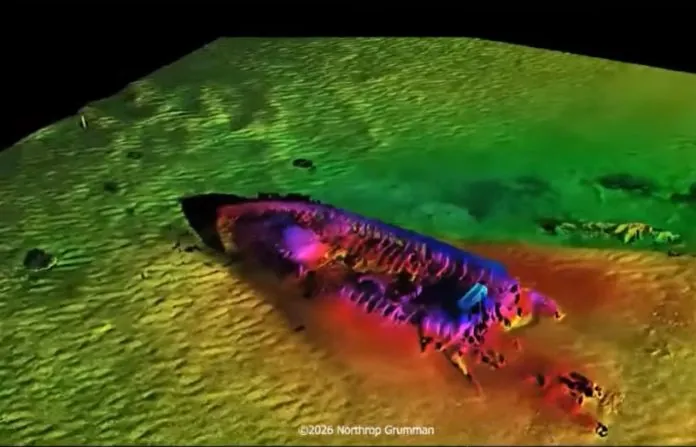
- Sonar relies on acoustic pulses to map environments where light can’t penetrate or visibility is low.
- The frequency of the transducer determines the balance between image resolution and the distance the signal can reach.
- Side-scan sonar is the industry standard for high-resolution seafloor mapping and identifying small objects.
- Environmental variables like water temperature, salinity, and pressure significantly influence the accuracy of acoustic data.
- Proper system calibration is essential to avoid distortion in the final digital imagery produced by the software.
How Sonar Imaging Works
The fundamental principle of sonar is the measurement of sound propagation. A transducer sends out a high-frequency sound wave; when this wave hits a target, it reflects back to the transducer. The device measures the time elapsed between the emission and the reception of the echo. Because the speed of sound in water is approximately 1,500 meters per second, the system uses this constant to calculate the exact range of the object.
Beyond mere distance, sonar imaging analyzes the strength of the return signal. Hard surfaces like rocks or metal hulls reflect strong echoes, appearing as bright spots on a display. Soft materials like mud or sand absorb more sound, resulting in weaker returns that appear darker. This contrast allows for the identification of geological features and man-made debris.
What Sonar Imaging Reveals
Sonar reveals a variety of underwater data points that are otherwise invisible to the naked eye. It maps the topography of the ocean floor, identifying ridges, trenches, and boulders. In maritime operations, it locates shipwrecks, pipelines, and cables. Furthermore, fisheries use specialized sonar to detect schools of fish, identifying their size, depth, and movement patterns within the water column.
| Feature Type | Detection Capability | Primary Use Case |
|---|---|---|
| Seafloor Topology | High Precision | Hydrographic surveying |
| Shipwreck Debris | Detailed Geometry | Archaeological discovery |
| Biological Schools | Density Mapping | Commercial fishing |
| Submerged Infrastructure | Structural Integrity | Pipeline inspections |
Types of Sonar Systems
Different sonar configurations serve specific purposes based on the required depth and resolution. Active sonar systems generate their own sound pulses, while passive systems simply listen for existing noise. Within the active category, there are several distinct designs used in modern marine exploration and defense.
Side-Scan Sonar
This system uses transducers mounted on a towfish or hull to sweep the seafloor. It creates a “slice” of the bottom, producing a shadow-like image that’s highly effective for finding small objects. Pro Tip: Always maintain a consistent towfish depth to ensure that the images produced by side-scan systems remain undistorted and easy to interpret during post-processing.
Multi-Beam Echosounder
A multi-beam system emits a fan-shaped array of sound waves. This configuration allows for the creation of a 3D map of the seafloor in a single pass. It’s the preferred method for large-scale hydrographic charting because it provides rapid, high-coverage data collection over vast areas of the ocean floor.
Synthetic Aperture Sonar
By processing signals gathered over a distance, synthetic aperture sonar achieves resolution independent of range. This allows for extremely high-definition imaging of small targets at significant distances, making it invaluable for deep-sea search operations where clarity is paramount.
Factors Influencing Acoustic Data
The accuracy of sonar imaging is heavily dependent on the physical properties of the water column. Sound travels differently depending on the medium’s density. The National Oceanic and Atmospheric Administration explains that sound speed changes based on water temperature, salinity, and pressure, all of which must be accounted for to maintain data integrity.
- Temperature gradients: Can bend sound waves and create ghost images.
- Salinity levels: Affect the speed of sound, requiring constant sensor calibration.
- Water pressure: Increases at depth, necessitating specialized hardware housing.
- Surface noise: Waves and bubbles can interfere with shallow-water sonar readings.
Preparing for Sonar Deployment
Before deploying a sonar unit, operators must verify that the transducer is free of biological fouling, such as barnacles or algae. Even minor obstructions can degrade the quality of the sound pulses and cause significant artifacts in the resulting imagery. Furthermore, ensuring that the navigation data, such as GPS coordinates and heading information, is synced with the sonar feed is critical for accurate mapping.
Interpreting Sonar Imagery
Reading sonar output requires training to distinguish between real objects and acoustic noise. Operators look for “shadows” behind objects to determine their height and shape. A long shadow suggests a tall object, while a short shadow indicates a low-profile feature. Warning: Never assume that a bright return on a display is a solid object; it could be a dense school of fish or a layer of thermal interference in the water column.
Comparison of Common Sonar Tools
| Hardware Brand | Common Model Type | Best Application |
|---|---|---|
| Teledyne Marine | Benthos Series | Deep-sea survey |
| Kongsberg Maritime | EM Series | Bathymetric mapping |
| Garmin | Striker Series | Recreational fishing |
| EdgeTech | 4125 Series | Search and recovery |
Common Troubleshooting Steps
When sonar images appear distorted or unclear, the issue usually stems from one of three areas: electrical interference, environmental factors, or hardware positioning. First, check all cable connections for corrosion or damage. Second, confirm that the transducer is mounted in a location free of turbulence or air bubbles created by the vessel’s hull. Finally, adjust the gain settings on the software interface to filter out background noise that may be masking the target.
Advancements in Underwater Imaging
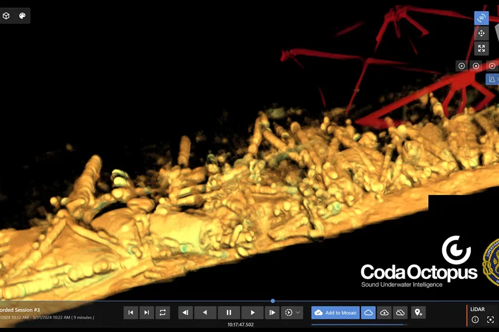
Recent developments in machine learning have revolutionized how sonar data is processed. Modern software can now automatically identify and classify objects based on their acoustic signature, reducing the manual labor required by human analysts. These advancements allow for real-time detection of hazards, which is essential for autonomous underwater vehicles navigating complex underwater environments.
Related guides
- Best Water Hammer Arrestors: How to Stop Pipe Noise Effectively in 2026
- Best Faucet Mounted Water Filters: How to Choose and Install in 2026
- Point of Use vs Whole House Water Heater: Which Is Right for You in 2026
Frequently Asked Questions
How deep can sonar see?
The depth range of sonar depends on the frequency used. Low-frequency systems can reach depths of several thousand meters, making them ideal for deep-sea exploration. Conversely, high-frequency systems provide superior image resolution but are limited to shallower depths, typically ranging from a few meters to a few hundred meters, as the sound energy dissipates faster in the water column.
Can sonar detect non-metallic objects?
Yes, sonar detects objects based on their acoustic impedance relative to the surrounding water, not their material composition. Wood, plastic, rock, and even biological matter like fish reflect sound waves effectively. The key factor is the density difference; as long as an object is denser or less dense than the water surrounding it, it will generate a detectable return signal for the receiver.
Why do images look distorted?
Distortion often results from vessel motion, such as pitching or rolling, which causes the transducer to change angle during data collection. Additionally, variations in the speed of sound due to thermoclines—layers of different water temperatures—can bend the sound waves, causing the image to appear warped. Using motion-compensation sensors helps correct these inaccuracies by realigning the data based on the vessel’s exact orientation.
Is sonar harmful to marine life?
High-intensity active sonar can be disruptive to marine mammals, particularly cetaceans that rely on their own biological sonar for navigation and communication. Regulatory bodies monitor sonar usage in sensitive habitats to mitigate potential impacts. Researchers are currently developing quieter, more efficient systems that minimize the acoustic footprint while maintaining the high-resolution imaging capabilities required for scientific and industrial maritime operations.
How do I improve image clarity?
To improve clarity, ensure the transducer face is perfectly clean and properly aligned with the water flow. Adjusting the “range” and “gain” settings on your display is also vital; reducing the range setting increases the pulse repetition rate, which provides more data points for a sharper image. Finally, ensure your software is updated to use the latest noise-reduction algorithms to filter out ambient interference.
Conclusion
Understanding how sonar imaging works allows you to leverage acoustic data for everything from recreational fishing to professional hydrographic surveying. By mastering the relationship between pulse frequency, environmental conditions, and signal interpretation, you can unlock a clear view of the aquatic world. Start by reviewing the technical specifications of your specific sonar hardware to optimize your settings for your next underwater mission.
